As part of the Colombia River Stories project involving the Universities of Glasgow, Portsmouth and Nottingham, the Atrato River Guardians, the Catholic Diocese of Quibdo, centro socio-juridico- Siembra, SCIAF and ABColombia with funding from ESRC-Newton Caldas, radar satellite monitoring was undertaken by Portsmouth University.
The aim of this project was to train the local communities, and the local university in the capital of Quibdo, in use of free satellite remote sensing to detect map and monitor sites of illegal mining.
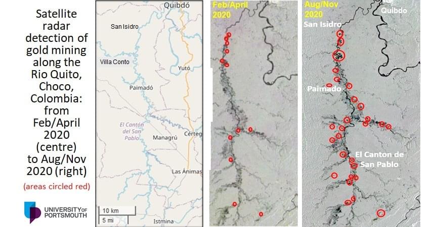
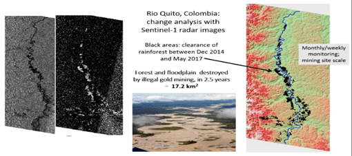
The image above of the Quito River was able to be used as evidence of the increase in illegal gold mining during the COVID-19 lock down. It illustrates the complete state abandonment of areas like the Quito River by the state during this period. Communities were also reporting that the illegal armed groups protecting these mining operations were restricting the movement of communities, dictating the rules by which they had to live, and destroying their territory; which is located in one of the top ten biodiversity hotspots of the world – Choco. This evidence was sent to the Constitutional Court monitoring committee, set up to monitor a Court ruling (T-622) giving rights to the Atrato River and its Tributaries (the Quito River is a tributary), as one of the Court’ rulings was that the State dismantle the illegal mining operations which are situated on floating platforms in the tributaries of the Atrato River.
Satellite optical imagery vs radar imagery
Sentinel-1 satellite imagery, freely downloadable from the European Space Agency, it was found to be very effective for detecting land cover types associated with alluvial gold mining.
The advantages/disadvantages, in rainforest contexts of satellite radar and optical imagery
Optical satellite imagery: was of minimum use due to cloud cover and cloud shadows. However, it was of some use in detecting and monitoring turbid water in rivers impacted by mining
Sentinel-1 radar imagery provided a relatively reliable all season / all weather means of detecting land cover features through cloud cover, a key issue when working in rainforest. It was adequate for detecting land cover changes associated with mining e.g. from tree cover to logged ground, logged ground to flooded pits, bare ground to scrub; also, detection of corner reflectors such as metal roofs, dredgers and excavators. A 6-day return period enables weekly and monthly monitoring of land cover changes.